 Mineral Exploration
Nhill Project – Western Victoria
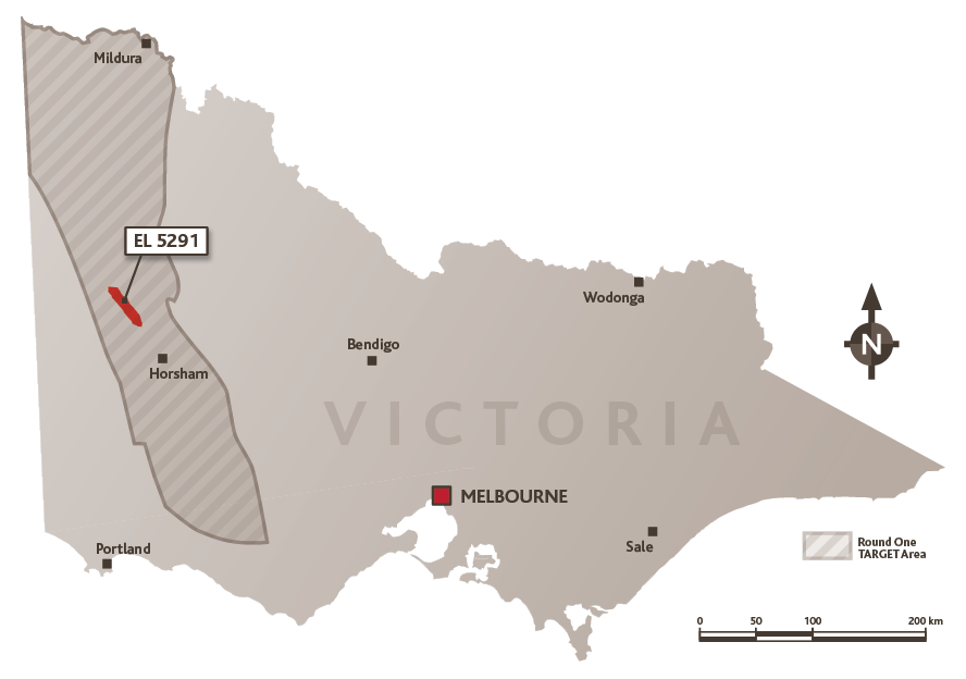
Austpac has been undertaking a low-key investigation of the gold and base metal potential within its wholly owned Exploration Licence 5291 near Nhill in western Victoria. The Nhill tenement was granted in August 2010 for a term of 5 years. It covers strong NNW-trending magnetic and gravity anomalies delineated by government survey data, and they represent features within the ancient basement that underlies the much younger sediments of the Murray Basin. The tenement was renewed in August 2015 for a further 4 year term.
Activities within EL 5291 are focused on a NNW-trending belt of Cambrian rocks known as the Mount Stavely Volcanic Complex, which are characterised by very strong features in the aeromagnetic and gravity data. Interest in this part of Victoria is being stimulated by positive technical studies by the Geological Survey of Victoria and the national agency, Geoscience Australia. Several resource companies are also enthusiastic about the mineral potential of this belt and they have initiated drilling programs on their tenements in western Victoria. The Mount Stavely units have been considered to be the equivalent to the well-mineralised Mount Read Volcanics of western Tasmania, while an alternative interpretation considers these rocks to be associated with an ancient tectonic boundary analogous to the Macquarie Arc in NSW, which hosts large porphyry copper deposits such as Cadia Ridgeway. This interpretation is supported by recent exploration which has identified a number of porphyry style prospects with encouraging anomalous mineralisation within the Mount Stavely Volcanics.
Austpac’s work within EL 5291 commenced with geophysical surveying to outline geological features below a thick blanket of younger sediments. During 2013 and 2014, Austpac drilled several vertical mud rotary holes through the shell-bearing marine sediments, which varied in thickness from 120m to 146m and then into the weathered section of the old basement rocks. The rig used for these holes was unable to penetrate into the fresh bedrock. Petrology indicates that the basement at this location comprises intensely altered volcanic rocks. The original mineral constituents are completely replaced by fine grained quartz, chlorite and epidote, with fine aggregates of sulphide minerals (pyrite and marcasite, with rare chalcopyrite and bornite). Local areas of hydrothermal brecciation were observed. Such propylitic alteration is typically found in the outer or upper portion of a porphyry system. Assays from the rock fragments are low reflecting metal depletion on the oxidised ancient land surface directly beneath the Murray Basin sediments. The work to date is encouraging and the company concluded that diamond drilling is required to test for a deep porphyry target at Nhill.
During 2014, Geoscience Australia (GA) completed a drilling program in the Stavely Zone, western Victoria to test geological models and assess the potential for a range of mineral systems, with a focus on porphyry copper-gold and volcanic-hosted massive sulphide systems. This collaborative project is being undertaken with the Geological Survey of Victoria, in partnership with the Deep Exploration Technologies Cooperative Research Centre. A total of 2,700 metres were drilled, and diamond core from 13 of the holes provided basement material for a range of analytical studies. A comprehensive report on this Government drilling program is expected to be released in late 2017. Austpac also provided GA with basement samples from its drilling operations at Nhill to assist their evaluation.
In June 2016, Austpac executed a Grant Agreement with the State of Victoria as represented by its Department of Economic Development, Jobs, Transport and Resources. The grant is part of the Victorian Government’s TARGET Initiative to co-fund innovative exploration in the far western portion of the state. The grant enables Austpac to recover 50% of approved expenditure upon completion of reporting to the TARGET team. The Grant includes three milestones, the first of which is an initial program of ground magnetic and gravity surveying which has been completed. The second milestone entails a vertical drillhole to test the basement below the younger Murray Basin sediments for porphyry copper-gold or volcanic-hosted massive sulphide systems. The final milestone consists of technical and financial reporting.
The new gravity and magnetic data from milestone 1 has facilitated computer modelling of the potential basement rock formations, to assist selection of the site for the milestone 2 drillhole. This hole will be completed during the second quarter of 2017. Milestone 3 activities will be accomplished in the following quarter.
 Return to top
